Follow the Scenic Trails to San Nicolo
- Sep 16, 2024
- 3 min read
From the the itinerary for September 6, 2024: After breakfast, head to Alba di Canazei (4,891’) where today’s hike begins. Follow a forest trail uphill to the Locai de Contrin mountain hut and through the beautiful Val Contrin. From the Malta Contrin mountain hut, continue your ascent to Passo San Nicola (7,703). Be wowed by impressive views of Marmolada’s peaks: Piccolo Vernel, Gran Vernel, Penia, and on Bretts. After a well-deserved lunch break, enjoy the panoramic view across Al San Nicola. Then, hike down through the picturesque valley - a landscape of flower0filled meadows and pretty wooden huts, all framed by spectacular peaks. Alternatively, you can opt for a panoramic train ride back.
Weather - cool and rainy
Planned hiking stats: 6 hours/9.5 miles - 3099 feet elevation gain/3312 loss
Actual hiking stats: 3.56 hours/8.18 miles - 2900 feet elevation gain/2150 feet loss (Komoot)
7.40 hours/9.48 miles - 2888 feet elevation gain (apple)


Weather looked threatening, so all weather gear was taken. We got bused to the start where we had a briefing and


then began!

Very hard uphill for 3 hours. Made it half way up with the front of the group and then hit a wall. It was more my breathing than muscular issue, so I am happy with my training and preparation. I am disappointed about my breathing and will try to have this looked at when I return to see if there's any physiological reason for it and if there's anything I can do.
Our first stop was a furnace which also had historical significance. The whole area was important during WW1. Before The War, Italy's territory was much larger and was broken up during the war - this break up pitted village against village and family against family. The fighting went back and forth through the Dolomites, gaining/losing small amounts of territory. The locals are still bitter about it. WW1 was much more significant to the "mountain people" than WW2 and created much hardship.


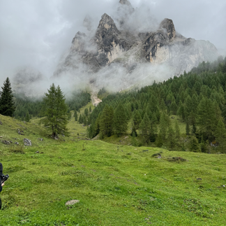
These are incredibly beautiful mountains and lovely hiking trails. Unfortunately, the clouds hid much of the view, but they also added a mystery. Views opened up suddenly (and closed just as suddenly).
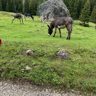
A few more steps beyond we saw some domestic wildlife - donkeys. There were several groups as we continued up. I was surprised not to see more cattle, but finally saw (and heard) a few.


We had some pretty views crossing a bridge before starting up again

As we started up towards our coffee break the view began opening up through the clouds


Coffee was at a refugio at 2016 meters...


More uphill, heavy breathing, and views as we continued going up...


We finally made it up to the saddle (2340 meters) (that's Lisa with her poles waving) and lunch (polenta with mushrooms) at a refugio


and then down the other side where I can finally breath... it's all downhill from here. We walked back through the tree line and forest. A lot of slippery tree roots, so no photos in the forest, but it was beautiful.


a fun selfie


It was wild flower season for something that looked like crocus, but is a flower called Colchhicum autumnalis. This is a poisonous flower that comes up in the autumn. I wish I had more photos, it was a beautiful flower that was like a carpet across the hills


We came down into a more gradual downhill and pastoral scenes and back to paved roads and the bus to take us back to the hotel. We saw/heard a farmer bringing his cattle back to the farm from the mountains


I had a great "disco" bubble bath soak which really felt great!
Dinner included a beer to end the day.

Comments